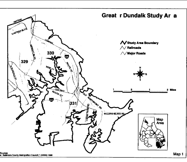
Last Thursday February 5, 2015 the North Point Peninsula Council, hosted representatives of the Department of Natural Resources to present then take comments and questions about the $248,160 bikeway construction project. The bikeway design is a 10 foot wide by 1.25 mile long gravel lane( 65,000 sq. ft. area) connecting Fort Howard’s Veterans Park parking lot with the North Point State Park parking lot.
The Background
The purposed $248,160 bikeway construction is part of a 15 year refinement of plans originating with the which aggregated all the communities of of Dundalk and the North Point Peninsula.It was drafted by 75 residents, business, religious and community leaders then adopted February 22, 2000 into the Baltimore County Master Plan 2010 through Resolution 20-00 introduced then by the Honorable John Olszewski Sr.
Click Photo to Enlarge
Following that Greater Dundalk-Edgemere Community Conservation Plan, “In 2004, the results of a community-wide survey (of 5000 mailed questionnaires to Edgemere, Fort Howard, and Miller’s Island, and Beachwood Estates of which 200 responded) and community forum were compiled by the North Point Peninsula Community Coordinating Council. In the survey and at the forum, residents were asked to respond to three questions:
What would you preserve in your community?
What would you create in your community?
What would you change in your community?
The results of this grassroots effort were outlined in an
Executive Summary that was submitted to Baltimore County Executive James Smith in August 2004. The objectives of the grassroots efforts were to “utilize the results of our community survey (of 200 out of 5000) as a revitalization checklist for
both strategic short and long term planning by the NPPCCC and
Baltimore County Government.”
Then a couple years passed and the “North Point Peninsula Revitalization Projects community Plan of December 2007 document,” was released “outlining the projects for the North Point Peninsula Community, and serves as a working document for the implementation of those projects.” The North Point Heritage Greenway Trail is briefed on page 20, which is The subject of the Thursday February 5, 2015 meeting as follows:
“Mr. Francis Taylor, a member of the NPPCCC, is working with
the National Parks Service to get assistance from the Rails-to-
Trails program for the creation of the North Point Heritage
Greenway Trail . The trail is also on the Baltimore County of
Recreation and Parks list of future projects, and included in the
Eastern Baltimore County Pedestrian and Bicycle Access Plan,
adopted by Baltimore County Council in November 2006.
A possible alignment of the trail would begin at the tip of the
North Point Peninsula and run along North Point Road,
connecting to the historic sites of Todd’s Inheritance and Shaw’s
Discovery. The trail would eventually connect to the North Point
Battlefield located to the north of Edgemere.”
Several years later, in January 2012 the the North Point Heritage Greenway Trail Draft Concept Plan was released.
January 3, 2012
Dear Friends:
The North Point Heritage Greenway Trail (NPT), the result of survey responses by residents of the North Point Peninsula, connects neighborhoods to historical sites, parks, schools, businesses, and government facilities. The unique historical contributions of the North Point Peninsula will be told along the NPT in a way both educational and interesting.
The North Point Peninsula Council officers and members are proud to sponsor the proposed North Point Heritage Greenway Trail for the benefit of our citizens of today and the future.
Harry Wujek, Jr. Francis Taylor
President Vice President and Chair, Trail Committee
The Meeting
As stated in the North Point Heritage Greenway Trail document “This conceptual trail plan has been prepared in partnership with Star-Spangled Banner National Historic Trail, the Maryland Department of Natural Resources, the Baltimore County Department of Planning and the Baltimore County Department of Recreation and Parks,” thus identifying what interests are driving the realization of the “plan.”
Starting with the Star-Spangled Banner National Historic Trail, the following picture is from page 13 of the Star-Spangled Banner National Historic Trail and Scenic Byway 2011 draft and the “trail,” is outlined in a green line overlaying North Point Road.
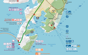
Click Photo to Enlarge
This “trail,” rendition delineates its origin at at a RED DOT at the south tip of the peninsula in the recently leased Veterans Administration property then northward following the North Point Road with the North Point Hertage Greenway Trail in thin yellow line parallel to the thick green line.
But what is most important that the “trail,” starts at the “North Point Landing,” denoted by the red dot then through the campus.
The following email from the Director of Communication Veterans Administration states no request has ever been made to use the campus as part of the “trail.”
Ms. Labuda: I am not familiar with any requests for a pedestrian/cyclist trail through the Fort Howard VA Medical Center campus prior to the execution of the Enhanced Use Lease for the property. My office was responsible for coordinating the requests for access to the Fort Howard campus prior to the execution of the Enhanced Use Lease (i.e. historic tours, overflow parking for Fort Howard Park events, TV production filming, etc.), but we did not receive any requests for a pedestrian/cyclist trail through the campus. Please let me know if you have any additional questions about the Fort Howard campus.
Thank you.
David Edwards
Chief, Public & Community Relations
VA Maryland Health Care System
The boundary of the North Point State Park is a blue dashed line. Some what of a nuance is the fact that blue dash line runs down the length of Howard Avenue from the Fort Howard Community Church to North Point Road.
Then the
The referenced “results of survey responses by residents of the North Point Peninsula,” refer to the results of an eleven year old survey performed by the North Point Peninsula Community Coordinating Council back in 2004 which Beachwood Estates, Edgemere, Millers Island, and Fort Howard are reported to have been sent 5000 mailed surveys.
Of those 5000 sent only 200 responded.
Following the survey a letter from the North Point Peninsula Community Coordinating Council was sent to then County Executive James Smith with an Executive Summary attached.
In December 2007, North Point Peninsula Community Plan 2007 was released which the “purpose of the North Point Peninsula Revitalization Projects Plan 2005-2007 is to highlight specific projects that promote the efforts of the Master Plan 2010, and as supported in the Dundalk-Edgemere Community Conservation Plan (adopted in 2000 and at which time coincidentally the Fort Howard VA Medical Center was closed), and then establish timelines for implementation. The projects in this document are reflective of the objectives listed in the Baltimore County Master Plan 2010 for the North Point Peninsula area, noting that “the County should take advantage of its waterfront” by enhancing tourism opportunities, promoting parks and other waterfront destinations, enhancing existing county parks and park programs, and enhancing land and water access to the water front.
The projects will be funded by the State and County. Some
projects have been highlighted by the Maryland Port
Administration’s Harbor Options Team for funding.
The Harbor Team was created in 2003 to advise the Maryland
Port Administration (MPA) on placement options for the Baltimore
Harbor as part of the state’s Dredged Material Management
Program. The Revitalization Projects Plan will serve as a tool for residents and community leaders to be informed of large public projects in progress so that they will be better situated to plan for their community’s future.”
First mention in North Point Peninsula Revitalization Projects Plan 2005-2007 the North Point Peninsula Heritage Greenway Trail Concept Plan was released in January, 2012
the was released
Although sadly not mentioned in the document, Mr. Wujek and Mr. Taylor’s dedication to our communities of the North Point Peninsula and the State of Maryland the should should be recognized for their years serving on the Harbor Team mentioned above. Thank you sirs.
Unfortunately the Maryland Department of Transportation is not mentioned directly as a source of funding for “projects,” from which the $248,160 grant is being sourced. Thank you past Secretary of Maryland Department of Transportation James Smith for your dedication to our communities on the peninsula.
This
The War of 1812 Celebration came and went. And with it a new feeling of the special place in American history the Fort Howard community is.
To share that American history a trail has been proposed. A trail starting at the south shore tip of the VA hospital grounds then up the peninsula out to North Point Boulevard.
The route memorializes the march of British marines heading to burn Baltimore in September 1814.
On February 5, 2015 at 6:30 PM at the Edgemere Elementary School Library the Maryland Department of Natural Resource is taking your comments, suggestions, and concerns on how you feel.
Page
6.) Segment Six: Veterans Park Section — approximately 1,560 feet
Veterans Park Section
►
Fort Howard
Veterans Park
The Veterans Park section will provide a link between Todd’s Inheritance and the recently constructed Baltimore
County “Fort Howard Veterans Park.” The trail would cross North Point Road, then parallel the Road ending at
Fort Howard Veterans Park. The term “Fort Howard” has more than one meaning on the North Point Peninsula.
In this case, Fort Howard refers to the name of a distinct, small residential community in which Fort Howard
Veterans Park resides. Further south of this community, at the southern tip of the peninsula, lies a much larger
park that is simply “Fort Howard Park.” Both of these parks are maintained by the Baltimore County Department
of Recreation and Parks
Scott Pappas
President
FHCA